This is an essay (longer read) about maps. There is no big message, no purpose, no call for action, none of that. Just recording and documenting of some reflections about maps. I don’t know where it came from. Suddenly I had enough notes to try to make something coherent out of it. Hope you enjoy the trip.
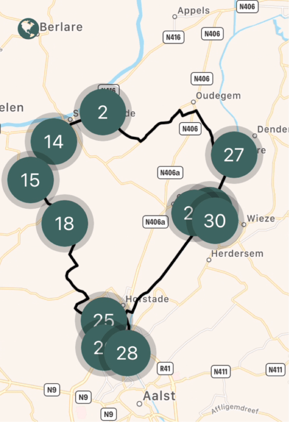
Modern Biking App Map – Notice point #27 – Denderbelle Lock
The theme of maps maybe emerged from my biking tours. Or from my recent tendency to do recordings: soundscapes – of probably better “silence-scapes” – of broken silence in nature. A sort of witnessing and documenting what was at that moment.
Maybe it emerged in preparing my upcoming performance for Finnovista in September: one of the themes is “learning” and I found that quality of observing says more about learning than teaching. So I used maps as a metaphor.
Maybe I am still intrigued by Simon Wardley’s situational awareness maps, which are all about observing, and mapping out position and movement.
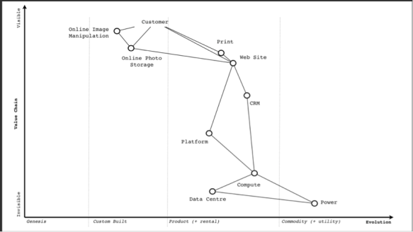
Simon Wardley - example of situational awareness map
Position on a map is often about geographical location and relations. But there is also the position in time: what was, what is, what can be. And like there is position of location, there is also position in time.
The time element hit me when I was bicycling along the river “Dender” and made a pit stop at the lock of Denderbelle. It’s a relatively small lock, and you can still walk over the doors of the lock to the other side of the river.
There I found this map on a tourism panel:

Old map of the area Aalst-Dendermonde – before 1769
Before 1769, the Dender was a meandering river that was very difficult to manoeuvre for ships. It was Charles de Lorraine – at that time Duchy of Brabant, Austrian Netherlands – who gave the order to straighten the meanders and build two new locks. Today, the river feels more like a canal that goes almost straight from Aalst to Dendermonde. It has a very well maintained towpath along silent borders, which makes it a nice bike trip.
Close to the lock, there is still the old ferry house, now inhabited by an artist. There was a chain pulling the ferry from one side to the other. Even today you can still see the stairs on the shore where people boarded.
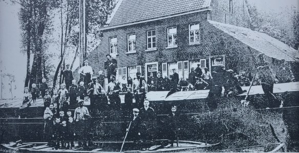
Denderbelle ferryhouse – Anno 1915
Maps as documents of past ways of living. Thanks to Richard Martin and Mark Storm, I discovered the Maps of Days by Grayson Perry.

Map of Days by Grayson Perry – 2013 – Etching 111.8 × 149.9 cm
Video with the artist Grayson Perry
‘A self-portrait as a fortified town, the wall perhaps my skin. Each day I worked on it I finished by marking the point with the date to highlight the passage of time in the production of art to reflect the forming and reforming of one’s identity. The ‘self’ I think is not a single fixed thing but a lifelong shifting performance. My sense of self is a tiny man kicking a can down the road.’
Grayson Perry
The map is an awesome alternative way to document one’s life. Richard Martin arguments that the question “what is your map” probably gives better answers on who you are than asking “What do you do?” or asking for your linear CV or portfolio:
“In the Map, Perry presents his complex personality and plural identity in the form of a walled city. Streets, buildings and other locales represent personal traits and behaviours, indicating a self-exploration that embraces both the positive and the negative, that poses questions, as well as providing answers, binding together truth and fiction. At the centre of Perry’s map is a labyrinthine garden, in which a figure walks, off-centre, pursuing ‘a sense of self’. Each time I look at the Map, either in a gallery or online, I question how my own version would differ from Perry’s. What words would I choose? What images?”
The same applies with the question “where do you come from?”. Should one say “a Chinese artist” or “an artist from China”? If you say “a Chinese artist” then you place the work of the artist in an ethnographic bubble, a cultural bubble. But when you talk about an artist coming from somewhere, you just connect the artist with a geographical starting point. I prefer the latter.

Map of Total Art by Qiu Zhijie – Ink on Paper – c. 5m length!
The work of Qiu Zhijie is fascinating. Check out this video interview with him and curator Davide Quadrio about the exposition ‘Qiu Zhijie: Journeys without Arrivals’ that was shown from 1 april – 24 september 2017 in the Van Abbemuseum in Eindhoven.
One year later, this video still resonates with me, so I made a full transcript of it, some extracts below:
Qiu Zhije is an artist, and he is producer, teacher, student, curator. He is a Master with capital “M” in Calligraphy. He is one of the most respected calligraphers in China.
As from 2010, I started drawing maps. If somebody asks me who I am, I answer I am a cartographer. Drawing maps is close to art, organizing exhibitions, teaching and researching. It is also writing. I feel it is a very multi-faceted way to show my talents as calligrapher.
For me, maps are a source of knowledge at arms’ length distance, knowledge you do not acquire on the field, but from the sky, like a bird’s eye perspective. Then you can move that knowledge on a flat surface, to understand the correlations between what belongs together. Things should not be understood individually, but in the context of their relation to each other. So maps have a lot of influence. Making maps is a way to re-establish the integrity of the world because they illustrate the correlations on how everything relates to each other.
Teaching has always been an important part of my life. By teaching I keep learning. I continue to actualize and renew myself. Although teaching takes a lot of time, it is never a loss of time. On the contrary, it allows me to learn. That’s why I define teachers as those who organize the process of learning”. I like to teach about things I don’t know much about. I like subjects that I am highly interested in, so we can dig deep to know more.

His work is extremely free of themes, but also so encyclopedic. And so easy to connect with the idea of museum as a collection of objects and things. At the same time, his work is also able to crush this idea of objects and really enter into a world of fantasy.
Maps are models. Maps mark the land, they are landmarks. They document the “land-scape”, as a sound-scape documents the sounds.
Artist Andrew Pekler even created a sonic map of phantom islands.
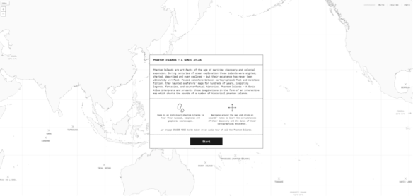
Phantom Islands – By Andrew Pekler – online experience, turn sound “on”
Andrew Pekler explains:
“The sweet spot for me is when a piece I have made can be simultaneously heard as both a field recording and as a completely composed, synthetic construct,”
Making maps is a sort of learning, a form of in-the-field-research and observation. Sharing with others what I am seeing, give context, some sense of coherence of position and direction/movement, and with some suggestions for maneuvering.
But in my case it is making pictures, writing and composing and creating a body of work from each trip. Field recordings, sound- and image-scapes like maps, at times creating a bizarre alienating, almost David Lynch kind of atmosphere, trying to resonate at another and additional level than the pure cognitive.
In that sense, I feel my current (art)work is getting closer to my real self, helps me to untether my soul, act as a witness, getting closer to alertness. With crispness, organic textures, precise rhythms,…

Natures Heartbeat – Online animation of earth’s heartbeat
In that sense, I am still doing the same as during my time as event curator. But the work is becoming more a documentary, a map, a set of interventions, interruptions and provocations that hopefully lead to higher states of alertness and aliveness.
Some kind of heartbeat that maps your open mind, heart, and will into a broader context.

PS: Mark Storm suggested I add the Buckminster Füller Dymaxion Map. He is right! How could I – as a true Bucky fan – have missed this one? 😉
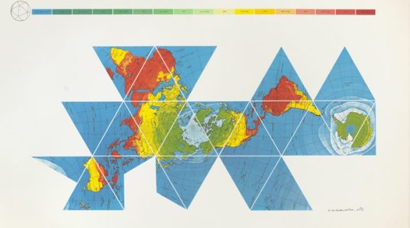
Also an interesting link via Mark Storm on this Bucky topic.

